 https://maltaclouds.net/wp-content/uploads/2019/09/Cu-congestus75.jpg?v=1569918568
2048
3072
admin
http://maltaclouds.net/wp-content/uploads/2018/10/logo-1-300x138.png
admin2019-07-16 17:14:082019-09-02 17:17:34Cu congestus
https://maltaclouds.net/wp-content/uploads/2019/09/Cu-congestus75.jpg?v=1569918568
2048
3072
admin
http://maltaclouds.net/wp-content/uploads/2018/10/logo-1-300x138.png
admin2019-07-16 17:14:082019-09-02 17:17:34Cu congestus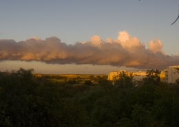 https://maltaclouds.net/wp-content/uploads/2019/05/Cu-congestus74.jpg?v=1569919546
1334
3015
admin
http://maltaclouds.net/wp-content/uploads/2018/10/logo-1-300x138.png
admin2019-04-15 17:54:312019-06-03 17:56:21Cu congestus
https://maltaclouds.net/wp-content/uploads/2019/05/Cu-congestus74.jpg?v=1569919546
1334
3015
admin
http://maltaclouds.net/wp-content/uploads/2018/10/logo-1-300x138.png
admin2019-04-15 17:54:312019-06-03 17:56:21Cu congestus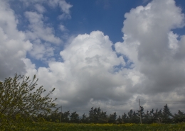 https://maltaclouds.net/wp-content/uploads/2019/05/Cu-congestus73.jpg?v=1569919545
2048
3072
admin
http://maltaclouds.net/wp-content/uploads/2018/10/logo-1-300x138.png
admin2019-04-13 17:52:002019-06-03 17:54:04Cu congestus
https://maltaclouds.net/wp-content/uploads/2019/05/Cu-congestus73.jpg?v=1569919545
2048
3072
admin
http://maltaclouds.net/wp-content/uploads/2018/10/logo-1-300x138.png
admin2019-04-13 17:52:002019-06-03 17:54:04Cu congestus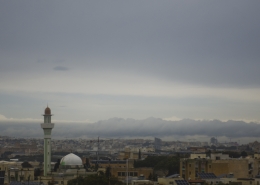 https://maltaclouds.net/wp-content/uploads/2019/05/Cu-arcus2.jpg?v=1569919543
1485
3072
admin
http://maltaclouds.net/wp-content/uploads/2018/10/logo-1-300x138.png
admin2019-04-07 17:48:462019-06-03 17:51:31Cu arcus
https://maltaclouds.net/wp-content/uploads/2019/05/Cu-arcus2.jpg?v=1569919543
1485
3072
admin
http://maltaclouds.net/wp-content/uploads/2018/10/logo-1-300x138.png
admin2019-04-07 17:48:462019-06-03 17:51:31Cu arcus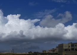 https://maltaclouds.net/wp-content/uploads/2019/05/Cu-congestus72.jpg?v=1569919538
1769
5008
admin
http://maltaclouds.net/wp-content/uploads/2018/10/logo-1-300x138.png
admin2019-03-03 17:47:022019-06-03 17:48:20Cu congestus
https://maltaclouds.net/wp-content/uploads/2019/05/Cu-congestus72.jpg?v=1569919538
1769
5008
admin
http://maltaclouds.net/wp-content/uploads/2018/10/logo-1-300x138.png
admin2019-03-03 17:47:022019-06-03 17:48:20Cu congestus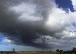 https://maltaclouds.net/wp-content/uploads/2019/05/Cu-congestus71.jpg?v=1569919531
3174
6756
admin
http://maltaclouds.net/wp-content/uploads/2018/10/logo-1-300x138.png
admin2019-02-03 17:44:322019-06-03 17:46:31Cu congestus
https://maltaclouds.net/wp-content/uploads/2019/05/Cu-congestus71.jpg?v=1569919531
3174
6756
admin
http://maltaclouds.net/wp-content/uploads/2018/10/logo-1-300x138.png
admin2019-02-03 17:44:322019-06-03 17:46:31Cu congestus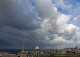 https://maltaclouds.net/wp-content/uploads/2019/05/Cu-mediocris18.jpg?v=1569919526
3888
5184
admin
http://maltaclouds.net/wp-content/uploads/2018/10/logo-1-300x138.png
admin2019-01-25 17:41:402019-06-06 20:58:46Cu mediocris
https://maltaclouds.net/wp-content/uploads/2019/05/Cu-mediocris18.jpg?v=1569919526
3888
5184
admin
http://maltaclouds.net/wp-content/uploads/2018/10/logo-1-300x138.png
admin2019-01-25 17:41:402019-06-06 20:58:46Cu mediocris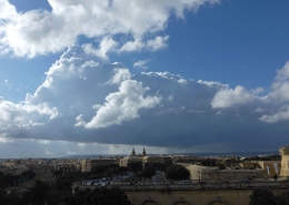 https://maltaclouds.net/wp-content/uploads/2019/05/Cu-congestus70.jpg?v=1569919517
3888
5184
admin
http://maltaclouds.net/wp-content/uploads/2018/10/logo-1-300x138.png
admin2018-12-07 17:38:522019-06-03 17:41:09Cu congestus
https://maltaclouds.net/wp-content/uploads/2019/05/Cu-congestus70.jpg?v=1569919517
3888
5184
admin
http://maltaclouds.net/wp-content/uploads/2018/10/logo-1-300x138.png
admin2018-12-07 17:38:522019-06-03 17:41:09Cu congestus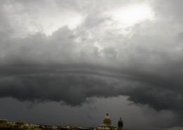 https://maltaclouds.net/wp-content/uploads/2019/05/Cu-arcus1.jpg?v=1569919515
1862
5894
admin
http://maltaclouds.net/wp-content/uploads/2018/10/logo-1-300x138.png
admin2018-12-01 17:35:212019-06-03 17:38:24Cu arcus
https://maltaclouds.net/wp-content/uploads/2019/05/Cu-arcus1.jpg?v=1569919515
1862
5894
admin
http://maltaclouds.net/wp-content/uploads/2018/10/logo-1-300x138.png
admin2018-12-01 17:35:212019-06-03 17:38:24Cu arcus https://maltaclouds.net/wp-content/uploads/2019/05/Cu-humilis8.jpg?v=1569919493
1695
3192
admin
http://maltaclouds.net/wp-content/uploads/2018/10/logo-1-300x138.png
admin2018-10-05 17:32:302019-06-03 17:34:38Cu humilis
https://maltaclouds.net/wp-content/uploads/2019/05/Cu-humilis8.jpg?v=1569919493
1695
3192
admin
http://maltaclouds.net/wp-content/uploads/2018/10/logo-1-300x138.png
admin2018-10-05 17:32:302019-06-03 17:34:38Cu humilis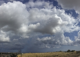 https://maltaclouds.net/wp-content/uploads/2019/05/Cu-congestus69.jpg?v=1569919486
3164
5900
admin
http://maltaclouds.net/wp-content/uploads/2018/10/logo-1-300x138.png
admin2018-09-14 17:29:262019-06-03 17:32:07Cu congestus
https://maltaclouds.net/wp-content/uploads/2019/05/Cu-congestus69.jpg?v=1569919486
3164
5900
admin
http://maltaclouds.net/wp-content/uploads/2018/10/logo-1-300x138.png
admin2018-09-14 17:29:262019-06-03 17:32:07Cu congestus https://maltaclouds.net/wp-content/uploads/2019/05/Cu-radiatus23.jpg?v=1569919474
3264
2448
admin
http://maltaclouds.net/wp-content/uploads/2018/10/logo-1-300x138.png
admin2018-06-26 17:27:022019-06-03 17:29:01Cu radiatus
https://maltaclouds.net/wp-content/uploads/2019/05/Cu-radiatus23.jpg?v=1569919474
3264
2448
admin
http://maltaclouds.net/wp-content/uploads/2018/10/logo-1-300x138.png
admin2018-06-26 17:27:022019-06-03 17:29:01Cu radiatus https://maltaclouds.net/wp-content/uploads/2019/05/Cu-mediocris17.jpg?v=1569919471
2448
3264
admin
http://maltaclouds.net/wp-content/uploads/2018/10/logo-1-300x138.png
admin2018-06-21 17:22:212019-06-06 20:54:04Cu mediocris
https://maltaclouds.net/wp-content/uploads/2019/05/Cu-mediocris17.jpg?v=1569919471
2448
3264
admin
http://maltaclouds.net/wp-content/uploads/2018/10/logo-1-300x138.png
admin2018-06-21 17:22:212019-06-06 20:54:04Cu mediocris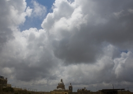 https://maltaclouds.net/wp-content/uploads/2019/05/Cu-congestus68.jpg?v=1569919472
1365
2048
admin
http://maltaclouds.net/wp-content/uploads/2018/10/logo-1-300x138.png
admin2018-06-20 17:13:552019-06-03 17:21:54Cu congestus
https://maltaclouds.net/wp-content/uploads/2019/05/Cu-congestus68.jpg?v=1569919472
1365
2048
admin
http://maltaclouds.net/wp-content/uploads/2018/10/logo-1-300x138.png
admin2018-06-20 17:13:552019-06-03 17:21:54Cu congestus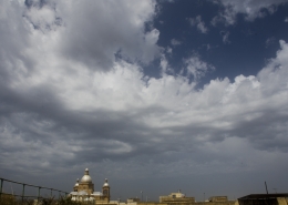 https://maltaclouds.net/wp-content/uploads/2019/05/Cu-congestus67.jpg?v=1569919467
1303
1920
admin
http://maltaclouds.net/wp-content/uploads/2018/10/logo-1-300x138.png
admin2018-05-20 17:11:072019-06-03 17:13:25Cu congestus
https://maltaclouds.net/wp-content/uploads/2019/05/Cu-congestus67.jpg?v=1569919467
1303
1920
admin
http://maltaclouds.net/wp-content/uploads/2018/10/logo-1-300x138.png
admin2018-05-20 17:11:072019-06-03 17:13:25Cu congestus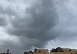 https://maltaclouds.net/wp-content/uploads/2018/09/Cu-praecipitatio6.jpg?v=1569919663
3210
3538
admin
http://maltaclouds.net/wp-content/uploads/2018/10/logo-1-300x138.png
admin2018-03-23 17:05:362019-06-03 17:10:23Cu praecipitatio
https://maltaclouds.net/wp-content/uploads/2018/09/Cu-praecipitatio6.jpg?v=1569919663
3210
3538
admin
http://maltaclouds.net/wp-content/uploads/2018/10/logo-1-300x138.png
admin2018-03-23 17:05:362019-06-03 17:10:23Cu praecipitatio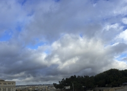 https://maltaclouds.net/wp-content/uploads/2019/05/Cu-mediocris16.jpg?v=1569919453
3073
5733
admin
http://maltaclouds.net/wp-content/uploads/2018/10/logo-1-300x138.png
admin2018-03-22 17:02:532019-06-03 17:04:59Cu mediocris
https://maltaclouds.net/wp-content/uploads/2019/05/Cu-mediocris16.jpg?v=1569919453
3073
5733
admin
http://maltaclouds.net/wp-content/uploads/2018/10/logo-1-300x138.png
admin2018-03-22 17:02:532019-06-03 17:04:59Cu mediocris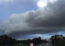 https://maltaclouds.net/wp-content/uploads/2019/05/Cu-radiatus22.jpg?v=1569919450
3126
5622
admin
http://maltaclouds.net/wp-content/uploads/2018/10/logo-1-300x138.png
admin2018-02-23 17:00:272019-06-03 17:02:21Cu radiatus
https://maltaclouds.net/wp-content/uploads/2019/05/Cu-radiatus22.jpg?v=1569919450
3126
5622
admin
http://maltaclouds.net/wp-content/uploads/2018/10/logo-1-300x138.png
admin2018-02-23 17:00:272019-06-03 17:02:21Cu radiatus https://maltaclouds.net/wp-content/uploads/2019/05/Cu-congestus66.jpg?v=1569919447
1954
2625
admin
http://maltaclouds.net/wp-content/uploads/2018/10/logo-1-300x138.png
admin2018-02-11 16:56:052019-06-03 16:59:48Cu congestus
https://maltaclouds.net/wp-content/uploads/2019/05/Cu-congestus66.jpg?v=1569919447
1954
2625
admin
http://maltaclouds.net/wp-content/uploads/2018/10/logo-1-300x138.png
admin2018-02-11 16:56:052019-06-03 16:59:48Cu congestus https://maltaclouds.net/wp-content/uploads/2019/05/Cu-congestus65.jpg?v=1569919444
2448
3264
admin
http://maltaclouds.net/wp-content/uploads/2018/10/logo-1-300x138.png
admin2018-01-28 15:55:002019-06-02 15:56:45Cu congestus
https://maltaclouds.net/wp-content/uploads/2019/05/Cu-congestus65.jpg?v=1569919444
2448
3264
admin
http://maltaclouds.net/wp-content/uploads/2018/10/logo-1-300x138.png
admin2018-01-28 15:55:002019-06-02 15:56:45Cu congestus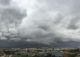 https://maltaclouds.net/wp-content/uploads/2019/05/Cu-mediocris-radiatus.jpg?v=1569919422
2913
5626
admin
http://maltaclouds.net/wp-content/uploads/2018/10/logo-1-300x138.png
admin2017-11-16 15:51:542019-06-02 15:54:39Cu mediocris radiatus
https://maltaclouds.net/wp-content/uploads/2019/05/Cu-mediocris-radiatus.jpg?v=1569919422
2913
5626
admin
http://maltaclouds.net/wp-content/uploads/2018/10/logo-1-300x138.png
admin2017-11-16 15:51:542019-06-02 15:54:39Cu mediocris radiatus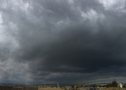 https://maltaclouds.net/wp-content/uploads/2019/05/Cu-congestus-praecipitatio.jpg?v=1569919556
3134
6950
admin
http://maltaclouds.net/wp-content/uploads/2018/10/logo-1-300x138.png
admin2017-11-02 15:49:562019-06-02 15:51:31Cu congestus praecipitatio
https://maltaclouds.net/wp-content/uploads/2019/05/Cu-congestus-praecipitatio.jpg?v=1569919556
3134
6950
admin
http://maltaclouds.net/wp-content/uploads/2018/10/logo-1-300x138.png
admin2017-11-02 15:49:562019-06-02 15:51:31Cu congestus praecipitatio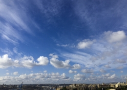 https://maltaclouds.net/wp-content/uploads/2019/05/Cu-humilis7.jpg?v=1569919554
2448
3264
admin
http://maltaclouds.net/wp-content/uploads/2018/10/logo-1-300x138.png
admin2017-10-27 15:46:182019-06-02 15:49:32Cu humilis
https://maltaclouds.net/wp-content/uploads/2019/05/Cu-humilis7.jpg?v=1569919554
2448
3264
admin
http://maltaclouds.net/wp-content/uploads/2018/10/logo-1-300x138.png
admin2017-10-27 15:46:182019-06-02 15:49:32Cu humilis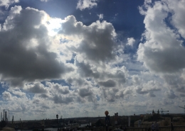 https://maltaclouds.net/wp-content/uploads/2019/05/Cu-mediocris15.jpg?v=1569919552
3108
6166
admin
http://maltaclouds.net/wp-content/uploads/2018/10/logo-1-300x138.png
admin2017-10-19 15:41:462019-06-02 15:45:11Cu mediocris
https://maltaclouds.net/wp-content/uploads/2019/05/Cu-mediocris15.jpg?v=1569919552
3108
6166
admin
http://maltaclouds.net/wp-content/uploads/2018/10/logo-1-300x138.png
admin2017-10-19 15:41:462019-06-02 15:45:11Cu mediocris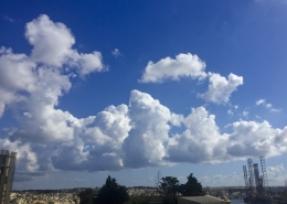 https://maltaclouds.net/wp-content/uploads/2019/05/Cu-congestus64.jpg?v=1569919551
2036
2710
admin
http://maltaclouds.net/wp-content/uploads/2018/10/logo-1-300x138.png
admin2017-10-10 15:39:322019-06-02 15:41:24Cu congestus
https://maltaclouds.net/wp-content/uploads/2019/05/Cu-congestus64.jpg?v=1569919551
2036
2710
admin
http://maltaclouds.net/wp-content/uploads/2018/10/logo-1-300x138.png
admin2017-10-10 15:39:322019-06-02 15:41:24Cu congestus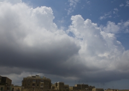 https://maltaclouds.net/wp-content/uploads/2018/09/Cu-congestus63.jpg?v=1569919955
1264
2009
admin
http://maltaclouds.net/wp-content/uploads/2018/10/logo-1-300x138.png
admin2017-07-16 18:26:592018-10-30 18:31:28Cu congestus
https://maltaclouds.net/wp-content/uploads/2018/09/Cu-congestus63.jpg?v=1569919955
1264
2009
admin
http://maltaclouds.net/wp-content/uploads/2018/10/logo-1-300x138.png
admin2017-07-16 18:26:592018-10-30 18:31:28Cu congestus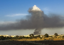 https://maltaclouds.net/wp-content/uploads/2018/09/Cu-mediocris-homogenitus.jpg?v=1569919947
1400
3065
admin
http://maltaclouds.net/wp-content/uploads/2018/10/logo-1-300x138.png
admin2017-05-22 18:34:152018-10-30 18:38:23Cu mediocris homo
https://maltaclouds.net/wp-content/uploads/2018/09/Cu-mediocris-homogenitus.jpg?v=1569919947
1400
3065
admin
http://maltaclouds.net/wp-content/uploads/2018/10/logo-1-300x138.png
admin2017-05-22 18:34:152018-10-30 18:38:23Cu mediocris homo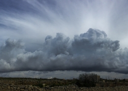 https://maltaclouds.net/wp-content/uploads/2018/09/Cu-radiatus21.jpg?v=1569919924
3144
8628
admin
http://maltaclouds.net/wp-content/uploads/2018/10/logo-1-300x138.png
admin2017-01-28 18:39:472018-10-30 18:42:55Cu radiatus
https://maltaclouds.net/wp-content/uploads/2018/09/Cu-radiatus21.jpg?v=1569919924
3144
8628
admin
http://maltaclouds.net/wp-content/uploads/2018/10/logo-1-300x138.png
admin2017-01-28 18:39:472018-10-30 18:42:55Cu radiatus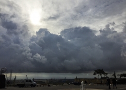 https://maltaclouds.net/wp-content/uploads/2018/09/Cu-congestus62.jpg?v=1569919956
2448
3264
admin
http://maltaclouds.net/wp-content/uploads/2018/10/logo-1-300x138.png
admin2016-12-09 18:43:562018-10-30 18:46:31Cu congestus
https://maltaclouds.net/wp-content/uploads/2018/09/Cu-congestus62.jpg?v=1569919956
2448
3264
admin
http://maltaclouds.net/wp-content/uploads/2018/10/logo-1-300x138.png
admin2016-12-09 18:43:562018-10-30 18:46:31Cu congestus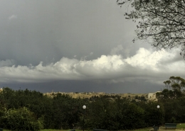 https://maltaclouds.net/wp-content/uploads/2018/09/Cu-radiatus20.jpg?v=1569919925
2078
5145
admin
http://maltaclouds.net/wp-content/uploads/2018/10/logo-1-300x138.png
admin2016-11-17 18:47:252018-10-30 18:49:53Cu radiatus
https://maltaclouds.net/wp-content/uploads/2018/09/Cu-radiatus20.jpg?v=1569919925
2078
5145
admin
http://maltaclouds.net/wp-content/uploads/2018/10/logo-1-300x138.png
admin2016-11-17 18:47:252018-10-30 18:49:53Cu radiatus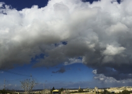 https://maltaclouds.net/wp-content/uploads/2018/09/Cu-radiatus19.jpg?v=1569919925
2966
9056
admin
http://maltaclouds.net/wp-content/uploads/2018/10/logo-1-300x138.png
admin2016-11-12 16:08:322018-10-31 16:11:01Cu radiatus
https://maltaclouds.net/wp-content/uploads/2018/09/Cu-radiatus19.jpg?v=1569919925
2966
9056
admin
http://maltaclouds.net/wp-content/uploads/2018/10/logo-1-300x138.png
admin2016-11-12 16:08:322018-10-31 16:11:01Cu radiatus https://maltaclouds.net/wp-content/uploads/2018/09/Cu-congestus61.jpg?v=1569919957
1053
2048
admin
http://maltaclouds.net/wp-content/uploads/2018/10/logo-1-300x138.png
admin2016-09-13 16:11:392018-10-31 16:14:07Cu congestus
https://maltaclouds.net/wp-content/uploads/2018/09/Cu-congestus61.jpg?v=1569919957
1053
2048
admin
http://maltaclouds.net/wp-content/uploads/2018/10/logo-1-300x138.png
admin2016-09-13 16:11:392018-10-31 16:14:07Cu congestus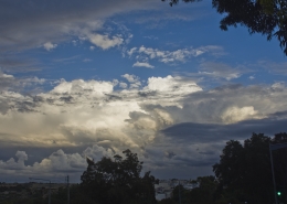 https://maltaclouds.net/wp-content/uploads/2018/09/Cu-congestus60.jpg?v=1569919958
1807
3001
admin
http://maltaclouds.net/wp-content/uploads/2018/10/logo-1-300x138.png
admin2016-09-07 16:16:182018-10-31 16:16:47Cu congestus
https://maltaclouds.net/wp-content/uploads/2018/09/Cu-congestus60.jpg?v=1569919958
1807
3001
admin
http://maltaclouds.net/wp-content/uploads/2018/10/logo-1-300x138.png
admin2016-09-07 16:16:182018-10-31 16:16:47Cu congestus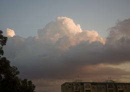 https://maltaclouds.net/wp-content/uploads/2018/09/Cu-congestus59.jpg?v=1569919959
1768
2817
admin
http://maltaclouds.net/wp-content/uploads/2018/10/logo-1-300x138.png
admin2016-09-02 16:23:102018-10-31 16:27:27Cu congestus
https://maltaclouds.net/wp-content/uploads/2018/09/Cu-congestus59.jpg?v=1569919959
1768
2817
admin
http://maltaclouds.net/wp-content/uploads/2018/10/logo-1-300x138.png
admin2016-09-02 16:23:102018-10-31 16:27:27Cu congestus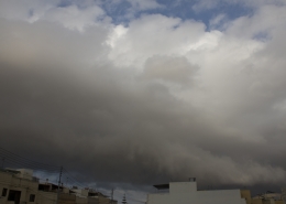 https://maltaclouds.net/wp-content/uploads/2018/09/Cu-congestus58.jpg?v=1569919959
1212
1881
admin
http://maltaclouds.net/wp-content/uploads/2018/10/logo-1-300x138.png
admin2016-08-23 16:27:582018-10-31 16:30:44Cu congestus
https://maltaclouds.net/wp-content/uploads/2018/09/Cu-congestus58.jpg?v=1569919959
1212
1881
admin
http://maltaclouds.net/wp-content/uploads/2018/10/logo-1-300x138.png
admin2016-08-23 16:27:582018-10-31 16:30:44Cu congestus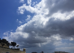 https://maltaclouds.net/wp-content/uploads/2018/09/Cu-congestus57.jpg?v=1569919960
2070
2838
admin
http://maltaclouds.net/wp-content/uploads/2018/10/logo-1-300x138.png
admin2016-08-08 16:35:282018-10-31 16:39:04Cu congestus
https://maltaclouds.net/wp-content/uploads/2018/09/Cu-congestus57.jpg?v=1569919960
2070
2838
admin
http://maltaclouds.net/wp-content/uploads/2018/10/logo-1-300x138.png
admin2016-08-08 16:35:282018-10-31 16:39:04Cu congestus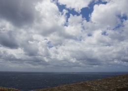 https://maltaclouds.net/wp-content/uploads/2018/09/Cu-mediocris14.jpg?v=1569919942
1365
2048
admin
http://maltaclouds.net/wp-content/uploads/2018/10/logo-1-300x138.png
admin2016-05-02 16:41:502018-10-31 16:44:04Cu mediocris
https://maltaclouds.net/wp-content/uploads/2018/09/Cu-mediocris14.jpg?v=1569919942
1365
2048
admin
http://maltaclouds.net/wp-content/uploads/2018/10/logo-1-300x138.png
admin2016-05-02 16:41:502018-10-31 16:44:04Cu mediocris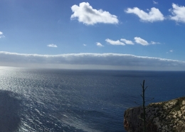 https://maltaclouds.net/wp-content/uploads/2018/09/Cu-radiatus18.jpg?v=1569919926
1951
5988
admin
http://maltaclouds.net/wp-content/uploads/2018/10/logo-1-300x138.png
admin2016-02-20 16:45:022018-10-31 16:47:46Cu radiatus
https://maltaclouds.net/wp-content/uploads/2018/09/Cu-radiatus18.jpg?v=1569919926
1951
5988
admin
http://maltaclouds.net/wp-content/uploads/2018/10/logo-1-300x138.png
admin2016-02-20 16:45:022018-10-31 16:47:46Cu radiatus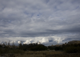 https://maltaclouds.net/wp-content/uploads/2018/09/Cu-congestus56.jpg?v=1569919961
1365
2048
admin
http://maltaclouds.net/wp-content/uploads/2018/10/logo-1-300x138.png
admin2016-01-24 16:48:492018-10-31 16:50:34Cu congestus
https://maltaclouds.net/wp-content/uploads/2018/09/Cu-congestus56.jpg?v=1569919961
1365
2048
admin
http://maltaclouds.net/wp-content/uploads/2018/10/logo-1-300x138.png
admin2016-01-24 16:48:492018-10-31 16:50:34Cu congestus https://maltaclouds.net/wp-content/uploads/2018/09/Cu-mediocris13.jpg?v=1569919943
2448
3264
admin
http://maltaclouds.net/wp-content/uploads/2018/10/logo-1-300x138.png
admin2015-12-31 16:51:072018-10-31 16:52:48Cu mediocris
https://maltaclouds.net/wp-content/uploads/2018/09/Cu-mediocris13.jpg?v=1569919943
2448
3264
admin
http://maltaclouds.net/wp-content/uploads/2018/10/logo-1-300x138.png
admin2015-12-31 16:51:072018-10-31 16:52:48Cu mediocris https://maltaclouds.net/wp-content/uploads/2018/09/Cu-congestus55.jpg?v=1569919962
1365
2048
admin
http://maltaclouds.net/wp-content/uploads/2018/10/logo-1-300x138.png
admin2015-11-27 16:53:362018-11-17 16:34:35Cu congestus
https://maltaclouds.net/wp-content/uploads/2018/09/Cu-congestus55.jpg?v=1569919962
1365
2048
admin
http://maltaclouds.net/wp-content/uploads/2018/10/logo-1-300x138.png
admin2015-11-27 16:53:362018-11-17 16:34:35Cu congestus https://maltaclouds.net/wp-content/uploads/2018/09/Cu-humilis6.jpg?v=1569919948
1365
2048
admin
http://maltaclouds.net/wp-content/uploads/2018/10/logo-1-300x138.png
admin2015-11-15 16:58:282018-10-31 17:00:44Cu humilis
https://maltaclouds.net/wp-content/uploads/2018/09/Cu-humilis6.jpg?v=1569919948
1365
2048
admin
http://maltaclouds.net/wp-content/uploads/2018/10/logo-1-300x138.png
admin2015-11-15 16:58:282018-10-31 17:00:44Cu humilis https://maltaclouds.net/wp-content/uploads/2018/09/Cu-congestus54.jpg?v=1569919963
2048
1365
admin
http://maltaclouds.net/wp-content/uploads/2018/10/logo-1-300x138.png
admin2015-11-07 17:06:292018-10-31 17:22:47Cu congestus
https://maltaclouds.net/wp-content/uploads/2018/09/Cu-congestus54.jpg?v=1569919963
2048
1365
admin
http://maltaclouds.net/wp-content/uploads/2018/10/logo-1-300x138.png
admin2015-11-07 17:06:292018-10-31 17:22:47Cu congestus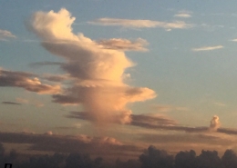 https://maltaclouds.net/wp-content/uploads/2018/09/5Nov15-IsolRainShwr.jpg?v=1569919988
2616
1860
admin
http://maltaclouds.net/wp-content/uploads/2018/10/logo-1-300x138.png
admin2015-11-05 17:27:552018-10-31 17:31:47Cu praecipitatio
https://maltaclouds.net/wp-content/uploads/2018/09/5Nov15-IsolRainShwr.jpg?v=1569919988
2616
1860
admin
http://maltaclouds.net/wp-content/uploads/2018/10/logo-1-300x138.png
admin2015-11-05 17:27:552018-10-31 17:31:47Cu praecipitatio https://maltaclouds.net/wp-content/uploads/2018/09/Cu-praecipitatio5.jpg?v=1569919935
1365
2048
admin
http://maltaclouds.net/wp-content/uploads/2018/10/logo-1-300x138.png
admin2015-10-31 17:32:472018-10-31 17:35:20Cu praecipitatio
https://maltaclouds.net/wp-content/uploads/2018/09/Cu-praecipitatio5.jpg?v=1569919935
1365
2048
admin
http://maltaclouds.net/wp-content/uploads/2018/10/logo-1-300x138.png
admin2015-10-31 17:32:472018-10-31 17:35:20Cu praecipitatio https://maltaclouds.net/wp-content/uploads/2018/09/Cu-virga2.jpg?v=1569919920
1365
2048
admin
http://maltaclouds.net/wp-content/uploads/2018/10/logo-1-300x138.png
admin2015-10-30 17:36:112018-11-17 16:32:07Cu virga
https://maltaclouds.net/wp-content/uploads/2018/09/Cu-virga2.jpg?v=1569919920
1365
2048
admin
http://maltaclouds.net/wp-content/uploads/2018/10/logo-1-300x138.png
admin2015-10-30 17:36:112018-11-17 16:32:07Cu virga https://maltaclouds.net/wp-content/uploads/2018/09/Cu-congestus53.jpg?v=1569919963
3182
6184
admin
http://maltaclouds.net/wp-content/uploads/2018/10/logo-1-300x138.png
admin2015-10-28 17:43:272018-10-31 17:50:46Cu congestus
https://maltaclouds.net/wp-content/uploads/2018/09/Cu-congestus53.jpg?v=1569919963
3182
6184
admin
http://maltaclouds.net/wp-content/uploads/2018/10/logo-1-300x138.png
admin2015-10-28 17:43:272018-10-31 17:50:46Cu congestus https://maltaclouds.net/wp-content/uploads/2018/09/Cu-praecipitatio4.jpg?v=1569919935
1584
2500
admin
http://maltaclouds.net/wp-content/uploads/2018/10/logo-1-300x138.png
admin2015-10-04 17:46:322018-10-31 17:49:32Cu praecipitatio
https://maltaclouds.net/wp-content/uploads/2018/09/Cu-praecipitatio4.jpg?v=1569919935
1584
2500
admin
http://maltaclouds.net/wp-content/uploads/2018/10/logo-1-300x138.png
admin2015-10-04 17:46:322018-10-31 17:49:32Cu praecipitatio https://maltaclouds.net/wp-content/uploads/2018/09/Cu-congestus52.jpg?v=1569919964
1365
2048
admin
http://maltaclouds.net/wp-content/uploads/2018/10/logo-1-300x138.png
admin2015-10-02 17:53:522018-10-31 17:58:00Cu congestus
https://maltaclouds.net/wp-content/uploads/2018/09/Cu-congestus52.jpg?v=1569919964
1365
2048
admin
http://maltaclouds.net/wp-content/uploads/2018/10/logo-1-300x138.png
admin2015-10-02 17:53:522018-10-31 17:58:00Cu congestus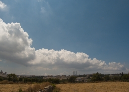 https://maltaclouds.net/wp-content/uploads/2018/09/Cu-radiatus16-1.jpg?v=1569919927
1536
2048
admin
http://maltaclouds.net/wp-content/uploads/2018/10/logo-1-300x138.png
admin2015-06-22 17:58:352018-10-31 18:02:14Cu radiatus
https://maltaclouds.net/wp-content/uploads/2018/09/Cu-radiatus16-1.jpg?v=1569919927
1536
2048
admin
http://maltaclouds.net/wp-content/uploads/2018/10/logo-1-300x138.png
admin2015-06-22 17:58:352018-10-31 18:02:14Cu radiatus https://maltaclouds.net/wp-content/uploads/2018/09/Cu-arcus.jpg?v=1569920761
1509
2879
admin
http://maltaclouds.net/wp-content/uploads/2018/10/logo-1-300x138.png
admin2015-05-18 18:03:082018-10-31 18:06:45Cu arcus
https://maltaclouds.net/wp-content/uploads/2018/09/Cu-arcus.jpg?v=1569920761
1509
2879
admin
http://maltaclouds.net/wp-content/uploads/2018/10/logo-1-300x138.png
admin2015-05-18 18:03:082018-10-31 18:06:45Cu arcus https://maltaclouds.net/wp-content/uploads/2018/09/Cu-humilis5-1.jpg?v=1569919949
1536
2048
admin
http://maltaclouds.net/wp-content/uploads/2018/10/logo-1-300x138.png
admin2015-04-25 18:07:402018-10-31 18:10:20Cu humilis
https://maltaclouds.net/wp-content/uploads/2018/09/Cu-humilis5-1.jpg?v=1569919949
1536
2048
admin
http://maltaclouds.net/wp-content/uploads/2018/10/logo-1-300x138.png
admin2015-04-25 18:07:402018-10-31 18:10:20Cu humilis https://maltaclouds.net/wp-content/uploads/2018/09/Cu-radiatus15-1.jpg?v=1569919928
1944
2592
admin
http://maltaclouds.net/wp-content/uploads/2018/10/logo-1-300x138.png
admin2015-03-27 18:11:132018-10-31 18:18:10Cu radiatus
https://maltaclouds.net/wp-content/uploads/2018/09/Cu-radiatus15-1.jpg?v=1569919928
1944
2592
admin
http://maltaclouds.net/wp-content/uploads/2018/10/logo-1-300x138.png
admin2015-03-27 18:11:132018-10-31 18:18:10Cu radiatus https://maltaclouds.net/wp-content/uploads/2018/09/Cu-praecipitatio3-1.jpg?v=1569919936
1536
2048
admin
http://maltaclouds.net/wp-content/uploads/2018/10/logo-1-300x138.png
admin2015-03-08 19:30:272018-11-02 19:33:45Cu praecipitatio
https://maltaclouds.net/wp-content/uploads/2018/09/Cu-praecipitatio3-1.jpg?v=1569919936
1536
2048
admin
http://maltaclouds.net/wp-content/uploads/2018/10/logo-1-300x138.png
admin2015-03-08 19:30:272018-11-02 19:33:45Cu praecipitatio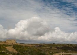 https://maltaclouds.net/wp-content/uploads/2018/09/Cu-congestus51-1.jpg?v=1569919965
1536
2048
admin
http://maltaclouds.net/wp-content/uploads/2018/10/logo-1-300x138.png
admin2015-02-28 19:34:252018-11-02 19:37:49Cu congestus
https://maltaclouds.net/wp-content/uploads/2018/09/Cu-congestus51-1.jpg?v=1569919965
1536
2048
admin
http://maltaclouds.net/wp-content/uploads/2018/10/logo-1-300x138.png
admin2015-02-28 19:34:252018-11-02 19:37:49Cu congestus https://maltaclouds.net/wp-content/uploads/2018/09/Cu-praecipitatio2-1.jpg?v=1569919937
1536
2048
admin
http://maltaclouds.net/wp-content/uploads/2018/10/logo-1-300x138.png
admin2015-01-24 19:38:242018-11-02 19:41:30Cu praecipitatio
https://maltaclouds.net/wp-content/uploads/2018/09/Cu-praecipitatio2-1.jpg?v=1569919937
1536
2048
admin
http://maltaclouds.net/wp-content/uploads/2018/10/logo-1-300x138.png
admin2015-01-24 19:38:242018-11-02 19:41:30Cu praecipitatio https://maltaclouds.net/wp-content/uploads/2018/09/Cu-undulatus-1.jpg?v=1569919922
1944
2592
admin
http://maltaclouds.net/wp-content/uploads/2018/10/logo-1-300x138.png
admin2015-01-23 19:42:202018-11-02 19:45:06Cu undulatus
https://maltaclouds.net/wp-content/uploads/2018/09/Cu-undulatus-1.jpg?v=1569919922
1944
2592
admin
http://maltaclouds.net/wp-content/uploads/2018/10/logo-1-300x138.png
admin2015-01-23 19:42:202018-11-02 19:45:06Cu undulatus https://maltaclouds.net/wp-content/uploads/2018/09/Cu-virga1-1.jpg?v=1569919921
1536
2048
admin
http://maltaclouds.net/wp-content/uploads/2018/10/logo-1-300x138.png
admin2014-12-31 19:45:462018-11-02 19:48:35Cu virga
https://maltaclouds.net/wp-content/uploads/2018/09/Cu-virga1-1.jpg?v=1569919921
1536
2048
admin
http://maltaclouds.net/wp-content/uploads/2018/10/logo-1-300x138.png
admin2014-12-31 19:45:462018-11-02 19:48:35Cu virga https://maltaclouds.net/wp-content/uploads/2018/09/Cu-radiatus14-1.jpg?v=1569919928
1944
2592
admin
http://maltaclouds.net/wp-content/uploads/2018/10/logo-1-300x138.png
admin2014-12-26 19:49:192018-11-02 21:12:00Cu radiatus
https://maltaclouds.net/wp-content/uploads/2018/09/Cu-radiatus14-1.jpg?v=1569919928
1944
2592
admin
http://maltaclouds.net/wp-content/uploads/2018/10/logo-1-300x138.png
admin2014-12-26 19:49:192018-11-02 21:12:00Cu radiatus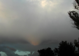 https://maltaclouds.net/wp-content/uploads/2018/09/Cu-tuba-2.jpg?v=1569919923
2592
1944
admin
http://maltaclouds.net/wp-content/uploads/2018/10/logo-1-300x138.png
admin2014-12-17 21:12:352018-11-02 21:15:20Cu tuba
https://maltaclouds.net/wp-content/uploads/2018/09/Cu-tuba-2.jpg?v=1569919923
2592
1944
admin
http://maltaclouds.net/wp-content/uploads/2018/10/logo-1-300x138.png
admin2014-12-17 21:12:352018-11-02 21:15:20Cu tuba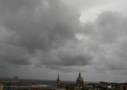 https://maltaclouds.net/wp-content/uploads/2018/09/Cu-pannus-1.jpg?v=1569919941
1944
2592
admin
http://maltaclouds.net/wp-content/uploads/2018/10/logo-1-300x138.png
admin2014-12-10 21:15:512018-11-02 21:18:42Cu pannus
https://maltaclouds.net/wp-content/uploads/2018/09/Cu-pannus-1.jpg?v=1569919941
1944
2592
admin
http://maltaclouds.net/wp-content/uploads/2018/10/logo-1-300x138.png
admin2014-12-10 21:15:512018-11-02 21:18:42Cu pannus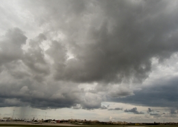 https://maltaclouds.net/wp-content/uploads/2018/09/Cu-praecipitatio1-1.jpg?v=1569919938
1536
2048
admin
http://maltaclouds.net/wp-content/uploads/2018/10/logo-1-300x138.png
admin2014-12-09 21:19:302018-11-02 21:22:11Cu praecipitatio
https://maltaclouds.net/wp-content/uploads/2018/09/Cu-praecipitatio1-1.jpg?v=1569919938
1536
2048
admin
http://maltaclouds.net/wp-content/uploads/2018/10/logo-1-300x138.png
admin2014-12-09 21:19:302018-11-02 21:22:11Cu praecipitatio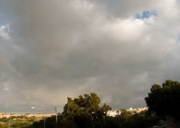 https://maltaclouds.net/wp-content/uploads/2018/09/Cu-mediocris12-1.jpg?v=1569919943
2304
3072
admin
http://maltaclouds.net/wp-content/uploads/2018/10/logo-1-300x138.png
admin2014-11-08 21:22:492018-11-02 21:25:01Cu mediocris
https://maltaclouds.net/wp-content/uploads/2018/09/Cu-mediocris12-1.jpg?v=1569919943
2304
3072
admin
http://maltaclouds.net/wp-content/uploads/2018/10/logo-1-300x138.png
admin2014-11-08 21:22:492018-11-02 21:25:01Cu mediocris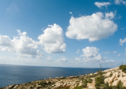 https://maltaclouds.net/wp-content/uploads/2018/09/Cu-fractus11-1.jpg?v=1569919951
1536
2048
admin
http://maltaclouds.net/wp-content/uploads/2018/10/logo-1-300x138.png
admin2014-10-25 21:25:402018-11-02 21:27:15Cu fractus
https://maltaclouds.net/wp-content/uploads/2018/09/Cu-fractus11-1.jpg?v=1569919951
1536
2048
admin
http://maltaclouds.net/wp-content/uploads/2018/10/logo-1-300x138.png
admin2014-10-25 21:25:402018-11-02 21:27:15Cu fractus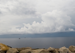 https://maltaclouds.net/wp-content/uploads/2018/09/Cu-radiatus13-1.jpg?v=1569919929
1536
2664
admin
http://maltaclouds.net/wp-content/uploads/2018/10/logo-1-300x138.png
admin2014-10-04 21:27:472018-11-02 21:29:50Cu radiatus
https://maltaclouds.net/wp-content/uploads/2018/09/Cu-radiatus13-1.jpg?v=1569919929
1536
2664
admin
http://maltaclouds.net/wp-content/uploads/2018/10/logo-1-300x138.png
admin2014-10-04 21:27:472018-11-02 21:29:50Cu radiatus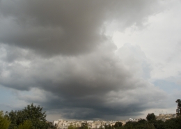 https://maltaclouds.net/wp-content/uploads/2018/09/Cu-congestus50-1.jpg?v=1569919966
1536
2048
admin
http://maltaclouds.net/wp-content/uploads/2018/10/logo-1-300x138.png
admin2014-10-03 21:30:292018-11-02 21:33:40Cu congestus
https://maltaclouds.net/wp-content/uploads/2018/09/Cu-congestus50-1.jpg?v=1569919966
1536
2048
admin
http://maltaclouds.net/wp-content/uploads/2018/10/logo-1-300x138.png
admin2014-10-03 21:30:292018-11-02 21:33:40Cu congestus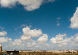 https://maltaclouds.net/wp-content/uploads/2018/09/Cu-fractus10-1.jpg?v=1569919951
1536
2048
admin
http://maltaclouds.net/wp-content/uploads/2018/10/logo-1-300x138.png
admin2014-05-03 21:37:372018-11-17 16:37:39Cu fractus
https://maltaclouds.net/wp-content/uploads/2018/09/Cu-fractus10-1.jpg?v=1569919951
1536
2048
admin
http://maltaclouds.net/wp-content/uploads/2018/10/logo-1-300x138.png
admin2014-05-03 21:37:372018-11-17 16:37:39Cu fractus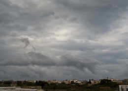 https://maltaclouds.net/wp-content/uploads/2018/09/Scud-cloud-1.jpg?v=1569919919
1536
2048
admin
http://maltaclouds.net/wp-content/uploads/2018/10/logo-1-300x138.png
admin2014-04-13 21:39:452018-11-02 21:41:38Scud cloud
https://maltaclouds.net/wp-content/uploads/2018/09/Scud-cloud-1.jpg?v=1569919919
1536
2048
admin
http://maltaclouds.net/wp-content/uploads/2018/10/logo-1-300x138.png
admin2014-04-13 21:39:452018-11-02 21:41:38Scud cloud https://maltaclouds.net/wp-content/uploads/2018/09/Cu-congestus48-1.jpg?v=1569919967
1536
2048
admin
http://maltaclouds.net/wp-content/uploads/2018/10/logo-1-300x138.png
admin2014-03-08 12:06:032018-11-17 16:47:20Cu congestus
https://maltaclouds.net/wp-content/uploads/2018/09/Cu-congestus48-1.jpg?v=1569919967
1536
2048
admin
http://maltaclouds.net/wp-content/uploads/2018/10/logo-1-300x138.png
admin2014-03-08 12:06:032018-11-17 16:47:20Cu congestus https://maltaclouds.net/wp-content/uploads/2018/09/Cu-congestus47.jpg?v=1569919969
1536
2048
admin
http://maltaclouds.net/wp-content/uploads/2018/10/logo-1-300x138.png
admin2014-03-08 11:58:372018-11-17 16:42:47Cu congestus
https://maltaclouds.net/wp-content/uploads/2018/09/Cu-congestus47.jpg?v=1569919969
1536
2048
admin
http://maltaclouds.net/wp-content/uploads/2018/10/logo-1-300x138.png
admin2014-03-08 11:58:372018-11-17 16:42:47Cu congestus https://maltaclouds.net/wp-content/uploads/2018/09/Cu-fractus9-1.jpg?v=1569919952
1536
2048
admin
http://maltaclouds.net/wp-content/uploads/2018/10/logo-1-300x138.png
admin2014-02-22 12:09:322018-11-03 12:15:00Cu fractus
https://maltaclouds.net/wp-content/uploads/2018/09/Cu-fractus9-1.jpg?v=1569919952
1536
2048
admin
http://maltaclouds.net/wp-content/uploads/2018/10/logo-1-300x138.png
admin2014-02-22 12:09:322018-11-03 12:15:00Cu fractus https://maltaclouds.net/wp-content/uploads/2018/09/Cu-congestus44-1.jpg?v=1569919973
1536
2048
admin
http://maltaclouds.net/wp-content/uploads/2018/10/logo-1-300x138.png
admin2014-01-25 12:18:352018-11-03 12:26:56Cu congestus
https://maltaclouds.net/wp-content/uploads/2018/09/Cu-congestus44-1.jpg?v=1569919973
1536
2048
admin
http://maltaclouds.net/wp-content/uploads/2018/10/logo-1-300x138.png
admin2014-01-25 12:18:352018-11-03 12:26:56Cu congestus https://maltaclouds.net/wp-content/uploads/2018/09/Cu-radiatus11-1.jpg?v=1569919930
1536
2048
admin
http://maltaclouds.net/wp-content/uploads/2018/10/logo-1-300x138.png
admin2013-12-10 12:27:542018-11-03 12:30:36Cu radiatus
https://maltaclouds.net/wp-content/uploads/2018/09/Cu-radiatus11-1.jpg?v=1569919930
1536
2048
admin
http://maltaclouds.net/wp-content/uploads/2018/10/logo-1-300x138.png
admin2013-12-10 12:27:542018-11-03 12:30:36Cu radiatus https://maltaclouds.net/wp-content/uploads/2018/09/Cu-praecipitatio-1.jpg?v=1569919939
1536
2048
admin
http://maltaclouds.net/wp-content/uploads/2018/10/logo-1-300x138.png
admin2013-12-03 12:33:562018-11-03 12:36:06Cu praecipitatio
https://maltaclouds.net/wp-content/uploads/2018/09/Cu-praecipitatio-1.jpg?v=1569919939
1536
2048
admin
http://maltaclouds.net/wp-content/uploads/2018/10/logo-1-300x138.png
admin2013-12-03 12:33:562018-11-03 12:36:06Cu praecipitatio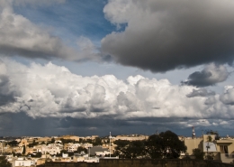 https://maltaclouds.net/wp-content/uploads/2018/09/Cu-congestus42-1.jpg?v=1569919974
1536
2048
admin
http://maltaclouds.net/wp-content/uploads/2018/10/logo-1-300x138.png
admin2013-12-03 12:31:052018-11-03 12:33:16Cu congestus
https://maltaclouds.net/wp-content/uploads/2018/09/Cu-congestus42-1.jpg?v=1569919974
1536
2048
admin
http://maltaclouds.net/wp-content/uploads/2018/10/logo-1-300x138.png
admin2013-12-03 12:31:052018-11-03 12:33:16Cu congestus https://maltaclouds.net/wp-content/uploads/2018/09/Cu-pileus3-1.jpg?v=1569919940
1536
2048
admin
http://maltaclouds.net/wp-content/uploads/2018/10/logo-1-300x138.png
admin2013-11-25 12:37:002018-11-17 16:40:21Cu pileus
https://maltaclouds.net/wp-content/uploads/2018/09/Cu-pileus3-1.jpg?v=1569919940
1536
2048
admin
http://maltaclouds.net/wp-content/uploads/2018/10/logo-1-300x138.png
admin2013-11-25 12:37:002018-11-17 16:40:21Cu pileus https://maltaclouds.net/wp-content/uploads/2018/09/Cu-mediocris11-1.jpg?v=1569919944
1536
2048
admin
http://maltaclouds.net/wp-content/uploads/2018/10/logo-1-300x138.png
admin2013-11-23 12:40:452018-11-03 12:42:55Cu mediocris
https://maltaclouds.net/wp-content/uploads/2018/09/Cu-mediocris11-1.jpg?v=1569919944
1536
2048
admin
http://maltaclouds.net/wp-content/uploads/2018/10/logo-1-300x138.png
admin2013-11-23 12:40:452018-11-03 12:42:55Cu mediocris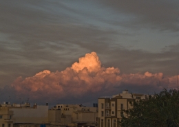 https://maltaclouds.net/wp-content/uploads/2018/09/Cu-congestus41-1.jpg?v=1569919975
1536
2048
admin
http://maltaclouds.net/wp-content/uploads/2018/10/logo-1-300x138.png
admin2013-11-04 12:43:272018-11-03 12:45:49Cu congestus
https://maltaclouds.net/wp-content/uploads/2018/09/Cu-congestus41-1.jpg?v=1569919975
1536
2048
admin
http://maltaclouds.net/wp-content/uploads/2018/10/logo-1-300x138.png
admin2013-11-04 12:43:272018-11-03 12:45:49Cu congestus https://maltaclouds.net/wp-content/uploads/2018/09/Cu-congestus39-1.jpg?v=1569919975
1536
2048
admin
http://maltaclouds.net/wp-content/uploads/2018/10/logo-1-300x138.png
admin2013-09-23 12:47:132018-11-03 12:50:04Cu congestus
https://maltaclouds.net/wp-content/uploads/2018/09/Cu-congestus39-1.jpg?v=1569919975
1536
2048
admin
http://maltaclouds.net/wp-content/uploads/2018/10/logo-1-300x138.png
admin2013-09-23 12:47:132018-11-03 12:50:04Cu congestus https://maltaclouds.net/wp-content/uploads/2018/09/Cu-congestus38-1.jpg?v=1569919976
1536
2048
admin
http://maltaclouds.net/wp-content/uploads/2018/10/logo-1-300x138.png
admin2013-09-22 12:52:302018-11-11 16:21:40Cu congestus
https://maltaclouds.net/wp-content/uploads/2018/09/Cu-congestus38-1.jpg?v=1569919976
1536
2048
admin
http://maltaclouds.net/wp-content/uploads/2018/10/logo-1-300x138.png
admin2013-09-22 12:52:302018-11-11 16:21:40Cu congestus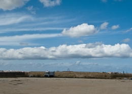 https://maltaclouds.net/wp-content/uploads/2018/09/Cu-radiatus10-1.jpg?v=1569919931
1047
2048
admin
http://maltaclouds.net/wp-content/uploads/2018/10/logo-1-300x138.png
admin2013-09-19 12:54:222018-11-17 16:49:23Cu radiatus
https://maltaclouds.net/wp-content/uploads/2018/09/Cu-radiatus10-1.jpg?v=1569919931
1047
2048
admin
http://maltaclouds.net/wp-content/uploads/2018/10/logo-1-300x138.png
admin2013-09-19 12:54:222018-11-17 16:49:23Cu radiatus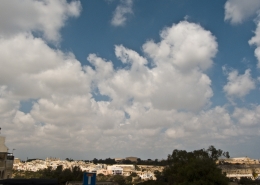 https://maltaclouds.net/wp-content/uploads/2018/09/Cu-fractus8-1.jpg?v=1569919953
1536
2048
admin
http://maltaclouds.net/wp-content/uploads/2018/10/logo-1-300x138.png
admin2013-08-25 21:35:082018-11-03 13:07:12Cu fractus
https://maltaclouds.net/wp-content/uploads/2018/09/Cu-fractus8-1.jpg?v=1569919953
1536
2048
admin
http://maltaclouds.net/wp-content/uploads/2018/10/logo-1-300x138.png
admin2013-08-25 21:35:082018-11-03 13:07:12Cu fractus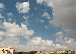 https://maltaclouds.net/wp-content/uploads/2018/09/Cu-fractus7-1.jpg?v=1569919954
1536
2048
admin
http://maltaclouds.net/wp-content/uploads/2018/10/logo-1-300x138.png
admin2013-08-10 13:08:382018-11-03 13:09:28Cu fractus
https://maltaclouds.net/wp-content/uploads/2018/09/Cu-fractus7-1.jpg?v=1569919954
1536
2048
admin
http://maltaclouds.net/wp-content/uploads/2018/10/logo-1-300x138.png
admin2013-08-10 13:08:382018-11-03 13:09:28Cu fractus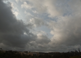 https://maltaclouds.net/wp-content/uploads/2018/09/Cu-humilis4-1.jpg?v=1569919950
1536
2048
admin
http://maltaclouds.net/wp-content/uploads/2018/10/logo-1-300x138.png
admin2013-04-07 13:10:112018-11-03 13:12:59Cu humilis
https://maltaclouds.net/wp-content/uploads/2018/09/Cu-humilis4-1.jpg?v=1569919950
1536
2048
admin
http://maltaclouds.net/wp-content/uploads/2018/10/logo-1-300x138.png
admin2013-04-07 13:10:112018-11-03 13:12:59Cu humilis https://maltaclouds.net/wp-content/uploads/2018/09/Cu-pileus2-1.jpg?v=1569919940
1536
2048
admin
http://maltaclouds.net/wp-content/uploads/2018/10/logo-1-300x138.png
admin2013-03-03 13:20:592018-11-03 13:23:46Cu pileus
https://maltaclouds.net/wp-content/uploads/2018/09/Cu-pileus2-1.jpg?v=1569919940
1536
2048
admin
http://maltaclouds.net/wp-content/uploads/2018/10/logo-1-300x138.png
admin2013-03-03 13:20:592018-11-03 13:23:46Cu pileus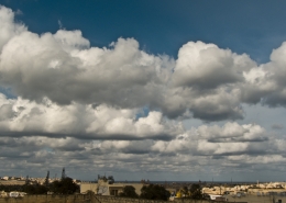 https://maltaclouds.net/wp-content/uploads/2018/09/Cu-radiatus9-1.jpg?v=1569919932
1536
2048
admin
http://maltaclouds.net/wp-content/uploads/2018/10/logo-1-300x138.png
admin2013-03-02 13:25:272018-11-03 13:28:02Cu radiatus
https://maltaclouds.net/wp-content/uploads/2018/09/Cu-radiatus9-1.jpg?v=1569919932
1536
2048
admin
http://maltaclouds.net/wp-content/uploads/2018/10/logo-1-300x138.png
admin2013-03-02 13:25:272018-11-03 13:28:02Cu radiatus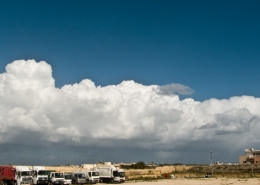 https://maltaclouds.net/wp-content/uploads/2018/09/Cu-radiatus8-1.jpg?v=1569919932
1077
2048
admin
http://maltaclouds.net/wp-content/uploads/2018/10/logo-1-300x138.png
admin2013-02-08 13:31:592018-11-03 13:40:54Cu radiatus
https://maltaclouds.net/wp-content/uploads/2018/09/Cu-radiatus8-1.jpg?v=1569919932
1077
2048
admin
http://maltaclouds.net/wp-content/uploads/2018/10/logo-1-300x138.png
admin2013-02-08 13:31:592018-11-03 13:40:54Cu radiatus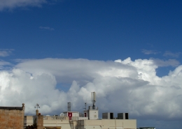 https://maltaclouds.net/wp-content/uploads/2018/09/Cu-velum-1.jpg?v=1569919921
2448
3264
admin
http://maltaclouds.net/wp-content/uploads/2018/10/logo-1-300x138.png
admin2013-02-08 13:28:552018-11-03 13:30:57Cu velum
https://maltaclouds.net/wp-content/uploads/2018/09/Cu-velum-1.jpg?v=1569919921
2448
3264
admin
http://maltaclouds.net/wp-content/uploads/2018/10/logo-1-300x138.png
admin2013-02-08 13:28:552018-11-03 13:30:57Cu velum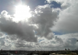 https://maltaclouds.net/wp-content/uploads/2018/09/Cu-mediocris9-1.jpg?v=1569919945
2448
3264
admin
http://maltaclouds.net/wp-content/uploads/2018/10/logo-1-300x138.png
admin2013-02-07 13:43:352018-11-03 13:45:27Cu mediocris
https://maltaclouds.net/wp-content/uploads/2018/09/Cu-mediocris9-1.jpg?v=1569919945
2448
3264
admin
http://maltaclouds.net/wp-content/uploads/2018/10/logo-1-300x138.png
admin2013-02-07 13:43:352018-11-03 13:45:27Cu mediocris https://maltaclouds.net/wp-content/uploads/2018/09/Cu-congestus35-1.jpg?v=1569919977
1536
2048
admin
http://maltaclouds.net/wp-content/uploads/2018/10/logo-1-300x138.png
admin2013-01-03 13:45:592018-11-03 13:48:18Cu congestus
https://maltaclouds.net/wp-content/uploads/2018/09/Cu-congestus35-1.jpg?v=1569919977
1536
2048
admin
http://maltaclouds.net/wp-content/uploads/2018/10/logo-1-300x138.png
admin2013-01-03 13:45:592018-11-03 13:48:18Cu congestus https://maltaclouds.net/wp-content/uploads/2018/09/Cu-mediocris7-1.jpg?v=1569919946
1536
2048
admin
http://maltaclouds.net/wp-content/uploads/2018/10/logo-1-300x138.png
admin2012-11-29 13:48:472018-11-03 13:51:16Cu mediocris
https://maltaclouds.net/wp-content/uploads/2018/09/Cu-mediocris7-1.jpg?v=1569919946
1536
2048
admin
http://maltaclouds.net/wp-content/uploads/2018/10/logo-1-300x138.png
admin2012-11-29 13:48:472018-11-03 13:51:16Cu mediocris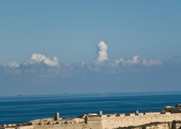 https://maltaclouds.net/wp-content/uploads/2018/09/Cu-congestus34-1.jpg?v=1569919978
1536
2048
admin
http://maltaclouds.net/wp-content/uploads/2018/10/logo-1-300x138.png
admin2012-11-25 13:51:432018-11-03 13:53:17Cu congestus
https://maltaclouds.net/wp-content/uploads/2018/09/Cu-congestus34-1.jpg?v=1569919978
1536
2048
admin
http://maltaclouds.net/wp-content/uploads/2018/10/logo-1-300x138.png
admin2012-11-25 13:51:432018-11-03 13:53:17Cu congestus https://maltaclouds.net/wp-content/uploads/2018/09/Cu-congestus32-1.jpg?v=1569919979
1536
2048
admin
http://maltaclouds.net/wp-content/uploads/2018/10/logo-1-300x138.png
admin2012-11-17 13:54:122018-11-03 13:56:34Cu congestus
https://maltaclouds.net/wp-content/uploads/2018/09/Cu-congestus32-1.jpg?v=1569919979
1536
2048
admin
http://maltaclouds.net/wp-content/uploads/2018/10/logo-1-300x138.png
admin2012-11-17 13:54:122018-11-03 13:56:34Cu congestus https://maltaclouds.net/wp-content/uploads/2018/09/Cu-fractus5-1.jpg?v=1569919954
1536
2048
admin
http://maltaclouds.net/wp-content/uploads/2018/10/logo-1-300x138.png
admin2012-11-10 13:57:112018-11-03 13:59:13Cu fractus
https://maltaclouds.net/wp-content/uploads/2018/09/Cu-fractus5-1.jpg?v=1569919954
1536
2048
admin
http://maltaclouds.net/wp-content/uploads/2018/10/logo-1-300x138.png
admin2012-11-10 13:57:112018-11-03 13:59:13Cu fractus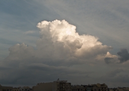 https://maltaclouds.net/wp-content/uploads/2018/09/Cu-congestus31-1.jpg?v=1569919979
1536
2048
admin
http://maltaclouds.net/wp-content/uploads/2018/10/logo-1-300x138.png
admin2012-10-23 13:59:522018-11-03 14:01:49Cu congestus
https://maltaclouds.net/wp-content/uploads/2018/09/Cu-congestus31-1.jpg?v=1569919979
1536
2048
admin
http://maltaclouds.net/wp-content/uploads/2018/10/logo-1-300x138.png
admin2012-10-23 13:59:522018-11-03 14:01:49Cu congestus https://maltaclouds.net/wp-content/uploads/2018/09/Cu-congestus30-1.jpg?v=1569919682
1536
2048
admin
http://maltaclouds.net/wp-content/uploads/2018/10/logo-1-300x138.png
admin2012-10-15 14:02:162018-11-03 14:04:00Cu congestus
https://maltaclouds.net/wp-content/uploads/2018/09/Cu-congestus30-1.jpg?v=1569919682
1536
2048
admin
http://maltaclouds.net/wp-content/uploads/2018/10/logo-1-300x138.png
admin2012-10-15 14:02:162018-11-03 14:04:00Cu congestus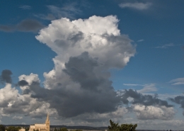 https://maltaclouds.net/wp-content/uploads/2018/09/Cu-congestus29-1.jpg?v=1569919683
1536
2048
admin
http://maltaclouds.net/wp-content/uploads/2018/10/logo-1-300x138.png
admin2012-09-15 14:04:292018-11-03 14:06:12Cu congestus
https://maltaclouds.net/wp-content/uploads/2018/09/Cu-congestus29-1.jpg?v=1569919683
1536
2048
admin
http://maltaclouds.net/wp-content/uploads/2018/10/logo-1-300x138.png
admin2012-09-15 14:04:292018-11-03 14:06:12Cu congestus https://maltaclouds.net/wp-content/uploads/2018/09/Cu-congestus28-1.jpg?v=1569919980
1536
2048
admin
http://maltaclouds.net/wp-content/uploads/2018/10/logo-1-300x138.png
admin2012-08-12 14:08:152018-11-03 14:09:50Cu congestus
https://maltaclouds.net/wp-content/uploads/2018/09/Cu-congestus28-1.jpg?v=1569919980
1536
2048
admin
http://maltaclouds.net/wp-content/uploads/2018/10/logo-1-300x138.png
admin2012-08-12 14:08:152018-11-03 14:09:50Cu congestus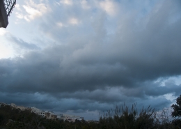 https://maltaclouds.net/wp-content/uploads/2018/09/Cu-radiatus7-1.jpg?v=1569919933
1536
2048
admin
http://maltaclouds.net/wp-content/uploads/2018/10/logo-1-300x138.png
admin2012-04-20 18:44:262018-11-08 18:46:16Cu radiatus
https://maltaclouds.net/wp-content/uploads/2018/09/Cu-radiatus7-1.jpg?v=1569919933
1536
2048
admin
http://maltaclouds.net/wp-content/uploads/2018/10/logo-1-300x138.png
admin2012-04-20 18:44:262018-11-08 18:46:16Cu radiatus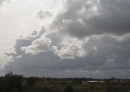 https://maltaclouds.net/wp-content/uploads/2018/09/Cu-congestus27-1.jpg?v=1569919981
1536
2048
admin
http://maltaclouds.net/wp-content/uploads/2018/10/logo-1-300x138.png
admin2012-02-06 18:46:512018-11-08 18:48:44Cu congestus
https://maltaclouds.net/wp-content/uploads/2018/09/Cu-congestus27-1.jpg?v=1569919981
1536
2048
admin
http://maltaclouds.net/wp-content/uploads/2018/10/logo-1-300x138.png
admin2012-02-06 18:46:512018-11-08 18:48:44Cu congestus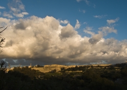 https://maltaclouds.net/wp-content/uploads/2018/09/Cu-radiatus6-2.jpg?v=1569919934
1536
2048
admin
http://maltaclouds.net/wp-content/uploads/2018/10/logo-1-300x138.png
admin2011-12-25 18:49:112018-11-08 18:50:56Cu radiatus
https://maltaclouds.net/wp-content/uploads/2018/09/Cu-radiatus6-2.jpg?v=1569919934
1536
2048
admin
http://maltaclouds.net/wp-content/uploads/2018/10/logo-1-300x138.png
admin2011-12-25 18:49:112018-11-08 18:50:56Cu radiatus https://maltaclouds.net/wp-content/uploads/2018/09/Cu-castellanus-1.jpg?v=1569919986
1536
2048
admin
http://maltaclouds.net/wp-content/uploads/2018/10/logo-1-300x138.png
admin2011-12-13 18:51:202018-11-08 18:53:05Cu castellanus
https://maltaclouds.net/wp-content/uploads/2018/09/Cu-castellanus-1.jpg?v=1569919986
1536
2048
admin
http://maltaclouds.net/wp-content/uploads/2018/10/logo-1-300x138.png
admin2011-12-13 18:51:202018-11-08 18:53:05Cu castellanus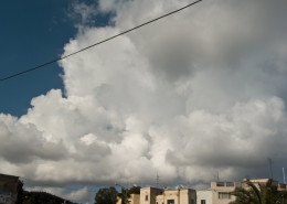 https://maltaclouds.net/wp-content/uploads/2018/09/Cu-congestus26-1.jpg?v=1569919982
1536
2048
admin
http://maltaclouds.net/wp-content/uploads/2018/10/logo-1-300x138.png
admin2011-12-04 18:53:332018-11-08 18:55:31Cu congestus
https://maltaclouds.net/wp-content/uploads/2018/09/Cu-congestus26-1.jpg?v=1569919982
1536
2048
admin
http://maltaclouds.net/wp-content/uploads/2018/10/logo-1-300x138.png
admin2011-12-04 18:53:332018-11-08 18:55:31Cu congestus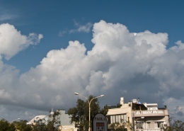 https://maltaclouds.net/wp-content/uploads/2018/09/Cu-congestus24-1.jpg?v=1569919983
1148
2048
admin
http://maltaclouds.net/wp-content/uploads/2018/10/logo-1-300x138.png
admin2011-11-12 18:56:282018-11-08 18:57:16Cu congestus
https://maltaclouds.net/wp-content/uploads/2018/09/Cu-congestus24-1.jpg?v=1569919983
1148
2048
admin
http://maltaclouds.net/wp-content/uploads/2018/10/logo-1-300x138.png
admin2011-11-12 18:56:282018-11-08 18:57:16Cu congestus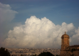 https://maltaclouds.net/wp-content/uploads/2018/09/Cu-congestus23-1.jpg?v=1569919983
1536
2048
admin
http://maltaclouds.net/wp-content/uploads/2018/10/logo-1-300x138.png
admin2011-11-02 18:59:072018-11-08 18:59:24Cu congestus
https://maltaclouds.net/wp-content/uploads/2018/09/Cu-congestus23-1.jpg?v=1569919983
1536
2048
admin
http://maltaclouds.net/wp-content/uploads/2018/10/logo-1-300x138.png
admin2011-11-02 18:59:072018-11-08 18:59:24Cu congestus https://maltaclouds.net/wp-content/uploads/2018/09/Cu-congestus22-1.jpg?v=1569919984
1536
2048
admin
http://maltaclouds.net/wp-content/uploads/2018/10/logo-1-300x138.png
admin2011-10-26 19:01:382018-11-08 19:02:05Cu congestus
https://maltaclouds.net/wp-content/uploads/2018/09/Cu-congestus22-1.jpg?v=1569919984
1536
2048
admin
http://maltaclouds.net/wp-content/uploads/2018/10/logo-1-300x138.png
admin2011-10-26 19:01:382018-11-08 19:02:05Cu congestus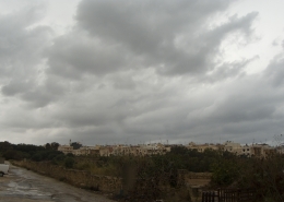 https://maltaclouds.net/wp-content/uploads/2018/09/Cu-mediocris6-1.jpg?v=1569919946
1280
2048
admin
http://maltaclouds.net/wp-content/uploads/2018/10/logo-1-300x138.png
admin2011-10-16 19:03:032018-11-08 19:05:28Cu mediocris
https://maltaclouds.net/wp-content/uploads/2018/09/Cu-mediocris6-1.jpg?v=1569919946
1280
2048
admin
http://maltaclouds.net/wp-content/uploads/2018/10/logo-1-300x138.png
admin2011-10-16 19:03:032018-11-08 19:05:28Cu mediocris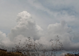 https://maltaclouds.net/wp-content/uploads/2018/09/Cu-congestus21-1.jpg?v=1569919985
1231
1969
admin
http://maltaclouds.net/wp-content/uploads/2018/10/logo-1-300x138.png
admin2011-09-28 19:05:532018-11-08 19:10:12Cu congestus
https://maltaclouds.net/wp-content/uploads/2018/09/Cu-congestus21-1.jpg?v=1569919985
1231
1969
admin
http://maltaclouds.net/wp-content/uploads/2018/10/logo-1-300x138.png
admin2011-09-28 19:05:532018-11-08 19:10:12Cu congestus https://maltaclouds.net/wp-content/uploads/2018/09/Cu-congestus20-1.jpg?v=1569919986
2048
1536
admin
http://maltaclouds.net/wp-content/uploads/2018/10/logo-1-300x138.png
admin2011-09-26 19:11:262018-11-08 19:13:00Cu congestus
https://maltaclouds.net/wp-content/uploads/2018/09/Cu-congestus20-1.jpg?v=1569919986
2048
1536
admin
http://maltaclouds.net/wp-content/uploads/2018/10/logo-1-300x138.png
admin2011-09-26 19:11:262018-11-08 19:13:00Cu congestusCu congestus
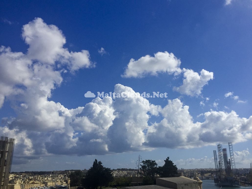
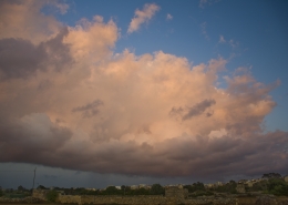
Formation of towering cumulus clouds as cooler air slides in towards the Ionian Sea from the Azores High over a much warmer surface. This causes such clouds to bubble up due to daytime heating and is indicated by ‘Thermal’ in the weather sounding below. The first picture is another photo of a donought shaped cumulus clouds (taken 13Oct17 morning) which are known to take many shapes. If the airmass had been unstable with a low pressure system such weather sounding was ideal for cumulonimbus clouds to develop. That week was dominated by a huge high pressure system as hurricane Ophelia pushed the Azores High eastwards with its central pressure over Central Europe.


Leave a Reply
Want to join the discussion?Feel free to contribute!